🏢FAIRVIEW DEVELOPMENTAL CENTER SPECIFIC PLAN TOWN HALL AND 👀PLANNING COMMISSION MEETING STUDY SESSION ON FDCSP
NOTE: The Fairview Developmental Center Specific Plan (FDCSP) will return to the Planning Commission on Monday, August 10 for a vote. If approved, it will then go to the City Council for approval. NOW IS THE TIME TO SPEAK UP ABOUT THIS IMPORTANT PROJECT, the largest housing project to ever hit Costa Mesa.
In addition, on August 17, 2026, the Planning Commission will hold a Special Meeting at 6:00 p.m. with the Measure K and Housing Element Rezoning as the topic. THIS IS ALSO IMPORTANT! We hope to see you at these meetings!
JULY 23, 2026 FAIRVIEW DEVELOPMENTAL CENTER SPECIFIC PLAN TOWN HALL
The meeting was supposed to be a community question-and-answer forum, responding to residents' requests for a public setting where questions could be asked and answers heard by everyone.
It was attended by approximately 80 people, including City Councilmembers Jeff Pettis, Mike Buley, Arlis Reynolds, and Andrea Marr. Planning Commissioner Jon Zich also attended, along with City Council candidates Kelly Brown, Daniel Thomas Morgan, and Steve Smith.
The presentation was preceded by time allowing residents to enter and circulate the posters on display. It was supposed to start around 6:10, but it was closer to 6:20 before things got under way. It was scheduled to last two hours, but it was about two and one-half hours before it ended. City Manager Cecila Gallardo-Daly kicked off the presentation by introducing Staff members and pointing out the officials in attendance. She made brief comments about the project, and then turned the presentation over to Carrie Tai, Community Development Director, who was assisted by members of the Placeworks consulting team.
The 20-minute presentation was an overview of the proposed Fairview Developmental Center (FDC) Specific Plan and explained the upcoming public hearing process. The presentation emphasized that the FDC planning effort has been underway for many years and is now entering its decision-making phase. Staff described the plan as a framework for transforming the former state institutional campus into a new mixed-use residential neighborhood with housing, affordable housing, parks, open space, supporting retail, and improved transportation connections, while continuing to gather public input before final decisions are made.
Summary of the Fairview Developmental Center (FDC) Specific Plan: The FDC Specific Plan is a proposed long-term redevelopment framework for the former Fairview Developmental Center site in Costa Mesa. It establishes how the site could be transformed into a new mixed-use neighborhood, setting rules for housing, land use, building design, parks, transportation, infrastructure, and maintenance.
Key Background: Fairview Developmental Center opened in 1959 as a state facility for people with developmental disabilities. The State announced plans to close the facility in 2016. In 2022, Senate Bill 188 authorized the site's disposition and gave Costa Mesa responsibility for leading the planning process. The State provided $3.5 million to support planning efforts.
Site Size and Ownership: Total property: approximately 110 acres. The State has retained 15 acres for the Southern Regional Emergency Operations Center and approximately 15-20 acres for supportive housing managed by the Department of Developmental Services. Roughly 80 acres remain within the City's redevelopment plan area.
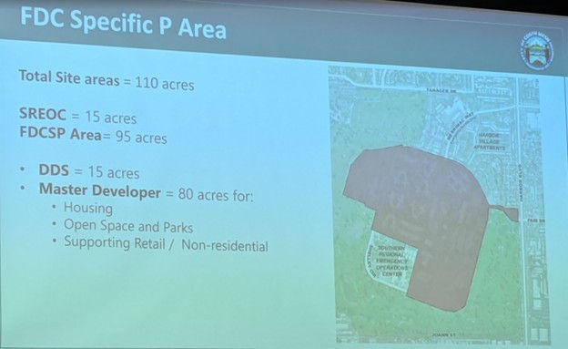
Housing and Development: Housing is intended to be the site's primary use, with a significant amount designated as affordable housing. Key figures discussed:
The City's Housing Element requires at least 2,300 housing units.
A financial study concluded about 3,450 units may be needed for redevelopment to be financially feasible.
The Environmental Impact Report (EIR) evaluated scenarios with up to 4,000 units.
The conceptual plan also includes:
Up to 35,000 square feet of neighborhood-serving commercial/retail space.
At least 14 acres of parks and open space.
Pedestrian, bicycle, and roadway improvements.
City staff emphasized that no development has been approved yet, and the land-use concept remains preliminary.
Transportation: A major issue is providing a second access road to the site. Studies found a second access point is necessary for transportation and safety. Several options were reviewed. Routes through nearby residential neighborhoods were deemed infeasible. The preferred connection would be to Harbor Boulevard.
Community Input: Staff reported extensive public engagement, including:
Community workshops and open houses.
Technical studies.
City Council study sessions.
Public reviews of the draft plan and EIR.
Staff stated they have responded to thousands of community comments throughout the process.
Environmental Review: A Draft Environmental Impact Report (EIR) analyzes the potential impacts of redevelopment and will be considered alongside the Specific Plan during the approval process. We have already provided comments, which can be found here:
In our opinion the presentation took too long and cut into the Q&A time, which meant the meeting was extended. Prior to the Q&A, Broc Coward, the City’s Community Relations Manager, admonished the audience to remain respectful and not go past the one minute per person allotted for questions. That seemed unnecessary, and it was as if Staff expected the audience to become unruly, which it never did (even though some folks from the Cornerstone community had to press for answers about a potential stop sign).
Audience Q & A: The discussion centered around five major topics: housing density, traffic and evacuation, affordable housing, open space/golf course impacts, and public services/infrastructure. While the residents were limited to one minute for their questions, Staff and the consultant didn’t have a time limit, and they tended to run on with their answers, sucking away time from the audience for questions. But that didn’t stop folks (like me) from asking multiple questions. Here is a summary of the questions by topic, and the answers delivered by Staff.
1. Housing Density and Number of Units. Many residents argued that:
4,000 units is too dense for the site.
Even 2,300 units feels excessive to some residents.
The project appears driven by financial feasibility rather than community fit.
Higher density may reduce open space and increase impacts on traffic, schools, and city services.
Staff Response: The 2,300-unit minimum comes from the City's Housing Element commitments. A financial analysis found that approximately 3,450 units are needed for redevelopment to be economically viable because of high demolition and infrastructure costs. 4,000 units is not the approved number, as no final unit count has been decided. It is simply the maximum density studied in the Environmental Impact Report (EIR). The Planning Commission will consider:
Financial feasibility.
Environmental impacts.
Housing requirements.
Public comments.
Site design and open space.
2. Affordable Housing: Residents asked:
Why not reduce affordable housing requirements instead of increasing density?
Will affordable housing be family-friendly?
How can the city ensure affordable units are actually built?
Why concentrate so much affordable housing on one site?
Staff Response: The affordable housing requirement comes from the City's adopted Housing Element and cannot simply be reduced. At the 2,300-unit level, about 960 units are required to be affordable. If the project grows beyond 2,300 units, the affordable unit requirement remains roughly the same, causing the affordable percentage to decrease. Affordable units must be comparable in size to market-rate units, including family-sized units. Future development approvals can require phasing plans to ensure affordable housing is built alongside market-rate housing. Staff noted that the Fairview site accounts for about 14% of Costa Mesa's overall affordable housing obligations, the remaining 86% of which is distributed across the city.
Public Support: Several speakers strongly supported affordable housing, arguing that:
Teachers, nurses, service workers, artists, seniors, and young families are being priced out of Costa Mesa.
Affordable housing is a community need, not separate from community interests.
The FDC site represents a rare opportunity to address the housing shortage.
3. Traffic, Access, and Evacuation: Traffic was the most frequently raised issue. Residents expressed concerns about:
Increased congestion on Harbor Boulevard and Fair Drive.
An estimated 20,000 to 24,000 daily vehicle trips.
School pickup/drop-off congestion.
Safety at Harbor/Fair intersections.
Neighborhood access, particularly at Cornerstone Lane.
Emergency evacuation of thousands of residents from only a few access points.
Staff Response: Traffic impacts were studied in the EIR using regional traffic models. Staff stated that a fully built project is projected to generate approximately 20,000 to 24,000 daily trips. According to modeling, projected traffic from the development is lower than regional forecasts for future traffic growth through 2045. The development will be required to fund:
New internal streets.
Roadway improvements.
A secondary access road.
Other supporting infrastructure.
Harbor Boulevard is not planned to be widened.
With respect to emergency access, Staff said emergency access would include:
1. Existing Fair Drive access.
2. A new secondary access road to Harbor Boulevard.
3. Emergency use of Merrimac Way.
4. Access through the Emergency Operations Center (EOC) during emergencies and across the golf course to the City Yard on Placentia.

Staff stated these options were studied and found adequate for emergency evacuation.
4. Schools and Public Services: Residents asked questions about:
School overcrowding
Parking shortages at schools
Police and fire service impacts
Increased demands on city services
Staff Response: The Newport-Mesa Unified School District informed the City that area schools have available capacity. The EIR estimates about 378 elementary students and about 384 middle/high school students. Staff said local schools have thousands of available seats according to district data. School impact fees would help fund future capital improvements. Additional property taxes and development impact fees help fund police, fire, and infrastructure needs.
5. Open Space, Parks, and the Golf Course: Residents questioned:
Why the site provides only about 14 acres of open space when some calculations indicate much more may be needed.
Why a secondary road is planned through the Costa Mesa Country Club golf course.
Whether the golf course could instead be used for additional housing or open space.
Whether the road is the first step toward eventual golf course loss.
Staff Response: The plan requires 4.26 acres of open space per 1,000 residents or an equivalent value. Because land is limited, "equivalent value" can include:
Recreational facilities.
Sports courts.
Aquatic facilities.
Park improvements elsewhere in the city.
The golf course is outside the FDC planning area.
Approximately six golf holes would be affected by the road and would be redesigned.
The City has retained a golf course architect to advise on future reconfiguration.
The goal is to preserve as much playability and course quality as possible.
6. Commercial Development: A former shopping center developer stated that no one would want to rent commercial space unless it fronted Harbor Boulevard. Other residents asked why any commercial uses are needed when Harbor Boulevard already provides shopping and services.
Staff Response: The proposed commercial component is relatively small, only up to 35,000 square feet, and its intended uses include neighborhood-serving amenities, such as coffee shops, daycare, small retail, and convenience services. The goal is to allow residents to walk to daily services.
7. Emergency Operations Center (EOC): Residents questioned:
Why the EOC was placed where it is.
Whether it should have been located elsewhere.
Whether it affects golf course impacts.
Staff Response: The EOC location was determined by the State, not the City. The State selected the location partly because of communications requirements and topography. The site functions as a regional emergency coordination center and is not intended as a public shelter.
8. Community Amenities: Residents asked whether the project would include:
Childcare centers.
Community gardens.
Health services.
Libraries.
Arts facilities.
Transit facilities.
Staff Response: The Specific Plan permits many of these uses. However, the plan is still a framework and not a detailed development proposal. Specific amenities would likely be negotiated later through development agreements with the future master developer.
9. Community Engagement: Several residents felt public participation has been low and that many nearby residents remain unaware of the project.
Staff Response: The City said it has conducted extensive outreach through:
Mailers to approximately 40,000 households.
Surveys.
Social media.
Nextdoor.
Email newsletters.
Libraries.
Public meetings.
Local media.
Staff said FDC engagement has exceeded participation levels typically seen in many city planning efforts.
Overall Takeaway: The meeting revealed a community divided between two major priorities:
Opponents argued the plan is too dense, will worsen traffic, impact schools and public services, reduce quality of life, and damage the golf course.
Supporters viewed the project as a rare chance to address Costa Mesa's housing affordability crisis and provide homes for workers, families, seniors, and younger generations.
Staff repeatedly emphasized that:
No development project has been approved.
No master developer has been selected, but the City will participate in the selection process.
The current document is a planning framework, not a final building proposal.
Future development proposals will return to the Planning Commission and City Council for additional review and public input.
Next Steps: Attend one or more of these meetings and give your input!
1. Planning Commission Study Session on July 27: There was review and discussion only, no decision. But there were some interesting comments by the Commissioners. More on that below.
2. Planning Commission Public Hearing on August 10: Recommendation on the Specific Plan and EIR forwarded to City Council.
3. City Council Public Hearing (tentatively September 15): Final consideration of the plan.
Our takeaway: While we appreciate the City finally getting around to this Town Hall, it is a bit late in the game. This meeting was another performative “check the box” meeting, and we felt the City ignored the concerns of residents with the excuse that the State mandates dictated the planning. In fact, the contract between the City and the State says otherwise. See excerpt from the contract below.
The entire process has been botched by the City because it either doesn’t want residents involved, it fears the residents, or because it just doesn’t care what we think. This started with failing to have a community advisory committee and ended with this meeting where residents were cut off at one minute.
However, there is still time to make your voice heard! Please attend the August 10 meeting at 6;00 p.m. at City Hall and express your views on this topic.
JULY 27 PLANNING COMMISSION MEETING. All Commissioners were present. There was also a fair number of the public in attendance. This meeting lasted nearly five (5!) hours. Aside from approval of minutes from a prior meeting, the Commission only considered four action items:
Tentative Parcel Map and Development Review for a Four-Unit Common Interest Development at 215 and 223 Mesa Drive
Development Review, Tentative Tract Map, and Density Bonus for a 15-Unit Residential Common Interest Development at 2075 Harbor Blvd. (Formerly Red-E-Rentals
Climate Action And Adaptation Plan, Safety Element Update, and Environmental Justice Policy Update
Fairview Developmental Center Specific Plan (FDCSP) Study Session
That last item was what proved to be the most interesting!
Public Comment. Liz Dorn Parker, President of the Coast Community College District Board of Trustees, requested that the City rezone parcels owned by the college district opposite of Orange Coast College on Adams Avenue to high-density housing.
There is no indication whether the State (the owner of the property) has designated these parcels as surplus land.
Commissioner Comments. Rob Dickson (District 5) declined to comment because of the anticipated length of the meeting..
David Martinez (District 5) announced several upcoming community events, and encouraged residents to participate in the city's GIS Strategic Plan survey, which is open through August 5 and aims to improve city mapping and location-based services. He informed the Commission that he will attend the next meeting virtually due to work commitments, and noted that he missed the FDC town hall due to illness.
Angely Andrade (District 4) recognized and thanked the Costa Mesa Alliance for Better Streets for hosting a free community bike repair event at Lions Park. She highlighted the participation of the Friends of the Library, who provided books and activities for youth. She also encouraged residents to attend National Night Out on August 4.
Jon Zich (District 1) responded to Ms. Dorn Parker’s comment by stating that to pursue her request she should submit a formal letter to the Director of Community Services and possibly involve the City Council. He also noted that including sites in the City's Housing Element could obligate housing development and limit flexibility for institutional uses.
For the broader public, he encouraged residents to stay informed about City activities by signing up for e-notifications through the city's website on topics such as Planning Commission and City Council meetings, committee meetings, community events, and city news, allowing them to receive information directly by email.
CONSENT CALENDAR: The single item on the Consent Calendar was approval of the minutes from the July 13, 2026 meeting. Martinez moved approval, Dickson seconded, and the motion carried by unanimously.
PUBLIC HEARINGS: There were two public hearings:
1. Tentative Parcel Map and Development Review for a Four-Unit Common Interest Development at 215 and 223 Mesa Drive. Chris Yeager, Senior Planner, presented a request from Obsidian Development to redevelop two existing single-family residential properties with a four-unit common interest development.
Project Overview: The 0.43-acre site is zoned R2-MD (Multiple-Family Residential, Medium Density) and designated Medium Density Residential under the General Plan. The project proposes four detached two-story homes, each with a two-car garage and private open space, at a density of 9.3 dwelling units per acre, below the maximum permitted density. The development complies with applicable standards, includes drought-tolerant landscaping and underground utilities, and will contribute toward the City's RHNA housing goals.
Commissioner Questions. The Commissioners discussed:
Driveway Design: Staff confirmed the driveway will be reviewed for compliance with City standards, including the required sidewalk area.
Landscaping and Trees: Staff explained the landscape plan is preliminary and the final tree count will be confirmed during plan review.
Tree Canopy: Staff stated the proposed African Sumac trees will mature into substantial shade trees that support canopy and climate goals.
Project Renderings: Commissioners requested more accurate landscaping depictions in future renderings. Staff noted the landscape plan, not the renderings, reflects the final tree locations and species.
Public Comment: None.
Motion and Vote. Zich moved to approve the item, which was seconded by Dickson. The motion passed 7-0.
2. Development Review, Tentative Tract Map, and Density Bonus for a 15-Unit Residential Common Interest Development at 2075 Harbor Blvd. (Formerly Red-E-Rentals. Victor Mendez, Senior Planner, presented the item. The Olson Company proposes to redevelop the former Red-E-Rentals site into a 15-unit common interest development consisting of 13 market-rate townhomes and two deed-restricted moderate-income units. The project includes six duplex buildings and one triplex, with building heights up to three stories.
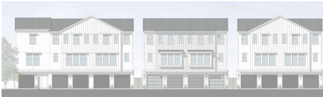
Requested approvals include a Development Review, Tentative Tract Map for condominium ownership, and a Density Bonus under State Density Bonus Law. Although the site could accommodate up to 32 units, the applicant is proposing 15 units.
The project qualifies for a Density Bonus through the provision of two moderate-income units and includes a request for one concession to allow existing overhead utility lines along Charle Street to remain rather than be undergrounded. The applicant also requests eight waivers from development standards related to setbacks, driveway width, building separation, open space, storage, and site design requirements.
The project provides 3,533 square feet of private open space and 3,676 square feet of common open space, with a waiver requested for the common open space requirement. The site is identified as both a Housing Element Opportunity Site and a Measure K Corridor site, contributing toward the City's housing goals.
Vehicular access would be provided from Charle Street, with an exit-only driveway on Harbor Boulevard. The project includes 41 parking spaces, enhanced drought-tolerant landscaping, shade trees, and screening vegetation throughout the site. Conditions of approval require compliance with applicable landscaping, lighting, and fencing standards.
The two affordable units were designated by the developer. They are the two least desirable units (on the end near traffic). For reference, the City of Los Angeles selects the affordable units in a project. It will not sign off on the deed restriction until the developer agrees to its selection, which could mean that one of the larger units could be designated affordable.
Commissioner Questions. Andrade and Dickson asked whether homeowners should receive a disclosure acknowledging the project's proximity to commercial and industrial uses, including automotive and repair businesses. Staff said the Zoning Code does not require such a disclosure, though the Commission could consider adding it as a project-specific condition. Dickson noted that similar buyer-notification requirements had been included in past Harbor Boulevard projects to address potential conflicts with existing businesses.
Martinez asked how the City would satisfy its No Net Loss obligations if a Housing Element site yielded fewer units than anticipated. Staff explained that State law requires replacement capacity within 180 days, but because the City is already updating its Housing Element and conducting a site-capacity analysis, the reduced unit count would be addressed through that process.
He also asked whether the two deed-restricted moderate-income units must be comparable to and dispersed among the market-rate units. Staff said State Density Bonus Law does not impose those requirements, and no applicable City regulations do so for this project.
The applicant gave a brief presentation, after which Andrade asked more questions. She praised the inclusion of moderate-income ownership units for creating first-time homeownership opportunities, as well as the proposed street trees and landscaping for supporting climate adaptation goals.
She asked whether prospective buyers would be able to tour the site and understand the surrounding commercial context before purchasing; the applicant confirmed they would. She also asked why Harbor Boulevard would serve as an exit-only driveway. The applicant explained that the design was intended to improve safety by limiting vehicle movements onto a fast-moving roadway.
In closing, the applicant noted that additional trees are expected within private rear yards beyond those shown in the common-area landscaping plan.
Public Comment. The first speaker expressed support for the project and specifically endorsed the exit-only access onto Harbor Boulevard, stating that Harbor is a heavily traveled roadway and that the proposed traffic circulation would improve safety and help the development integrate smoothly into the surrounding neighborhood.
The second speaker supported the addition of affordable housing on an underutilized site and asked whether the all-electric homes could include solar panels to further reduce housing costs for residents.
The third speaker welcomed the inclusion of moderate-income affordable units and requested clarification regarding the length of the affordability covenant. She noted the community's need for lower-income rental housing but expressed support for the affordable ownership opportunities provided by the project.
Commissioner Comments. Andrade referenced comments from a former property owner, Tim Lewis, regarding potential traffic and parking impacts on Charle Street. She noted that additional vehicle trips associated with the project could affect an area where on-street parking is already heavily utilized and suggested that roadway striping or other traffic-control measures might help clarify traffic movements and improve safety.
Staff responded that these concerns could be reviewed by Public Works during the project's design and engineering phase.
Later in the discussion, Commissioner Andrade sought clarification regarding the affordability covenant for the deed-restricted units. Staff confirmed that, while an earlier draft management plan referenced a 45-year term, the project's affordable housing agreement would require affordability to be maintained for 55 years.
Motion and Vote. Dickson then moved to approve the item, which was seconded by Andrade. The motion passed unanimously.
OLD BUSINESS: None.
NEW BUSINESS: Two items were heard:
1. Climate Action And Adaptation Plan, Safety Element Update, and Environmental Justice Policy Update. Note: This Item returns to the Planning Commission on Monday, August 10. Amber Gregg, Contract Project Manager with Community Catalyst, Anna McGill, Advanced Planning Manager, Charles Springer, Energy and Sustainability Services Manager, and consultant team members presented an overview of three related planning efforts currently underway: the Climate Action and Adaptation Plan (CAAP), Safety Element Update, and Environmental Justice (EJ) Policy Update. These City-initiated efforts are intended to comply with State law, implement Housing Element Program 2G, and advance Costa Mesa's goals related to climate resilience, public safety, and environmental justice.
Staff requested feedback from the Planning Commission before returning on August 10 with the documents for formal consideration. The initiatives include:
Climate Action and Adaptation Plan (CAAP): A long-range policy framework aimed at reducing greenhouse gas emissions and preparing the community for climate-related impacts. The CAAP focuses on municipal leadership, public education, incentives, and partnerships rather than new regulatory requirements. A 2023 greenhouse gas inventory found that transportation accounts for approximately 63% of local emissions. The draft CAAP contains 108 implementation actions across eight sectors, including transportation, energy, water, waste, urban forestry, and municipal operations.
Safety Element Update: A required update to the General Plan's Safety Element that incorporates current hazard data, climate adaptation strategies, and the City's 2022 Local Hazard Mitigation Plan. The update addresses flooding, drought, extreme heat, wildfire risks, emergency preparedness, and infrastructure resilience while ensuring consistency with State law and other planning documents.
Environmental Justice Policy Update: Required under State law, the update seeks to promote equitable access to healthy, safe, and livable communities. Staff identified existing General Plan policies that address environmental justice issues and developed new or revised policies focused on topics such as parks and recreation access, tree canopy expansion, active transportation, healthy food access, public participation, and infrastructure investment in environmental justice communities.
Staff highlighted an extensive public outreach effort that included workshops, surveys, stakeholder meetings, Earth Day events, pop-up outreach, an open house, and online engagement. Draft documents were released for public review, and staff will incorporate public and Planning Commission feedback before returning with recommendations and adoption hearings.
Commissioner Questions and Comments: Dickson asked which documents remained open for public comment. Staff confirmed that all three documents, the CAAP, Safety Element Update, and Environmental Justice Update, were still available for public review. Dixon requested that future survey summaries include more detailed information on response methods and response breakdowns. He also asked that future presentations more clearly connect proposed CAAP actions to greenhouse gas reductions and provide comparisons with Orange County and regional climate plans.
Martinez asked whether the CAAP would undergo CEQA review. Staff explained that, rather than preparing a separate CEQA-qualified climate plan, the City intends to rely on greenhouse gas analysis already being prepared through the Neighborhoods Where We All Belong (NWWAB) effort. Staff stated that future projects would rely on that analysis rather than the CAAP itself.
Martinez also asked about greenhouse gas reduction targets. Staff explained that the CAAP includes a 2030 target consistent with SB 32 (40% below 1990 levels) and a longer-term target consistent with AB 1279 (85% below 1990 levels).
Regarding the Safety Element, Martinez asked whether maps and figures would be updated. Staff said affected maps have been revised using the best available data, including updated fire hazard maps, while some older figures remain because newer data is unavailable.
Martinez further questioned how the CAAP's 108 actions translate into measurable emissions reductions. Staff replied that Appendix D quantifies expected reductions and performance indicators for individual actions. Martinez expressed concern that actions framed as "consider" or "explore" could technically be completed without reducing emissions and encouraged a stronger emphasis on measurable outcomes. Staff responded that the plan includes a reduction buffer above required targets, annual monitoring, and the flexibility to adjust actions over time.
When Martinez asked how implementation would be monitored, staff explained that Appendix E serves as an implementation matrix identifying responsible departments and tracking measures. Staff indicated that annual reporting tools would be provided, while future reporting procedures would be determined by the City. Martinez suggested annual reviews by the Planning Commission or City Council and recommended exploring e-bikes as part of City fleet reduction efforts.
Andrade recommended incorporating suggestions submitted by the Coastal Corridor Alliance, including:
Promoting native landscaping and habitat restoration.
Expanding urban greening efforts.
Increasing use of low-impact development and stormwater infiltration strategies.
Supporting watershed protection, sustainable materials, and reduced plastic use.
Strengthening coordination with environmental organizations and public agencies.
Expanding environmental justice, walkability, safety, and educational initiatives.
Improving access to healthy food, including farmers markets.
Enhancing recycling education and compliance efforts.
Exploring community facilities, such as future Shalimar improvements, as cooling centers, or emergency-response resources.
Staff received the comments for consideration during the continuing review process.
Zich expressed support for the Safety Element updates and hazard mapping improvements. He asked who would be responsible for implementing Environmental Justice policies. Staff explained that implementation responsibilities would vary by topic, with departments such as Transportation and Community Development responsible for applicable policies.
Zich also asked whether the Environmental Justice policies would return to the Commission. Staff confirmed that the policies would be incorporated into updated General Plan chapters and brought back at the August 10 meeting. He commented that the CAAP currently reads more as a vision document than an implementation document and requested additional information regarding costs, implementation responsibilities, and impacts on residents.
Public Comment: None.
Motion and Vote. Dickson moved to receive and file the item, which was seconded by Andrade. The motion carried unanimously.
There was a break, during which there was a power outage, but the generators at City Hall kicked in and the meeting resumed at about the two hour and twenty-minute mark.
2. Fairview Developmental Center Specific Plan (FDCSP) Study Session. Melinda Dacy, Principal Planner, Economic and Development Services Director Carrie Tai, Ana McGill, Planning Manager, and Paul Martin, Transportation Services Manager, along with consultants from PlaceWorks presented an overview of the Fairview Developmental Center (FDC) Specific Plan, covering the site's history, community outreach, proposed land use plan, environmental review, and next steps. The presentation largely mirrored information previously shared at the recent community town hall.
Staff explained that the draft Specific Plan studies a development program of up to 4,000 residential units, which was identified through the City's financial feasibility analysis as the most financially viable scenario. Staff noted that the California Department of General Services (DGS) submitted a letter dated July 2, 2026, supporting the 4,000-unit concept, and stating that it is consistent with applicable legislation, planning objectives, and feasibility considerations. It is curious that the City felt the need to solicit this letter. This makes us wonder if it will be pushing for the maximum 4,000 units.
The presentation also highlighted key infrastructure needs. Existing onsite infrastructure would require substantial replacement, including the water distribution and sewer systems, although adequate water supply is available. Future infrastructure improvements would be funded through development impact fees established through a nexus study.
Revisions Following Public Review: Staff summarized revisions made to the draft Specific Plan following the March-April 2026 public review period, including:
Refinements to the vision statement and guiding principles.
Clarification of project phasing and implementation procedures.
Updates to land-use classifications to reflect related zoning code amendments.
Removal of residential parking minimums to align with prior City Council direction.
Environmental Impact Report: The draft Environmental Impact Report (EIR) evaluated the Specific Plan under the California Environmental Quality Act (CEQA) and identified several significant environmental impacts. Even with mitigation measures, the EIR found significant and unavoidable impacts related to:
Air quality
Biological resources
Cultural and historic resources
Greenhouse gas emissions
Key concerns included increased emissions, impacts to aquatic resources, and effects on historic resources associated with the Fairview Developmental Center Historic District.
Alternatives Evaluated: The EIR evaluated several alternatives, including:
No Project / No Development Alternative
Partial Adaptive Reuse of Historic Resources Alternative
The Partial Adaptive Reuse Alternative was identified as the environmentally superior alternative because it preserves portions of the historic district while still achieving most project objectives.
Note that the City did not consider the reduction of units to the 2,300 units in the Housing Element as an alternative.
It is highly unlikely that the Partial Adaptive Reuse Alternative will be selected by the Master Developer, as it is not the economically superior alternative. That is because it is easier to tear everything down and then rebuild. However, the redevelopment of the old Fred C. Nelles School for Boys, aka “juvie” when I lived in Whittier, did retain some of the old buildings on that former state-owned site. Those buildings are now a food hall and entertainment area. Only time will tell if the Master Developer gives the Partial Adaptive Reuse Alternative any consideration.
The Planning Commission's role at this meeting was to receive the presentation, provide feedback, and accept the report. Staff will return with the Specific Plan, General Plan amendments, and zoning amendments at a future Planning Commission meeting. Following Planning Commission recommendations, the City Council will consider:
Adoption of the Specific Plan
Related General Plan and zoning amendments
Certification of the EIR
If adopted, the State is expected to select a master developer who must implement the project consistent with the Specific Plan.

Public Comment: At nearly the three-hour mark, it was time for what the about sixteen members of the public had been waiting for. The comments lasted nearly 35 minutes. Here is a summary:
Public comments reflected a wide range of opinions, but several major themes emerged.
1. Traffic, Access, and Safety Concerns (Most Common Concern): Many speakers expressed concern that the proposed development is too large for a site with limited access. Key concerns included:
The project would rely primarily on one main roadway, with commenters arguing that one access point is inadequate for up to 4,000 housing units.
Several residents compared the proposal to existing neighborhoods that have numerous entrances and exits despite having fewer homes. Concerns were raised about:
Traffic congestion on Harbor Boulevard, Placentia Avenue, Victoria Street, and surrounding neighborhoods.
Emergency evacuation and public safety.
Delayed emergency response times for both existing residents and future residents.
Impacts from special events such as the OC Fair, which some felt were not adequately considered in traffic studies.
Some residents questioned the decision not to use Merrimac Way as a full secondary access route.
2. Desire for More Open Space and Recreation: Many residents argued that the site represents a rare opportunity to create significant parkland. Common requests included:
Limiting development to the minimum 2,300-unit scenario.
Creating larger community parks, sports fields, and recreation facilities.
Preserving more green space rather than maximizing housing density.
Providing additional amenities for youth sports, including:
Flag football
Soccer
Rugby
Pickleball
Community gathering spaces
Several speakers stated that Costa Mesa already faces shortages of playing fields and recreational facilities.
3. Opposition to 4,000 Housing Units: Numerous commenters urged the city to reduce the scale of development. Their concerns included:
The 4,000-unit concept would create excessive density.
Increased population would strain infrastructure, parks, schools, police, fire services, and transportation systems.
The project could significantly alter Costa Mesa's character.
Some argued that the increase from 2,300 to 4,000 units primarily adds market-rate units while providing little additional affordable housing.
Several residents advocated for a smaller project that still fulfills housing obligations while reducing impacts.
4. Affordable Housing Discussion: Views differed on affordable housing.
Supportive comments:
Helps with Costa Mesa's long-standing affordable housing shortage.
The need for substantial affordable housing production.
The importance of approving the plan with as many affordable units as possible.
One speaker specifically requested safeguards to ensure:
Affordable housing is built alongside market-rate housing.
Future developers cannot delay or avoid constructing affordable units.
Critical comments:
Increasing total units does not proportionally increase affordable housing.
The project may ultimately favor market-rate development.
High-density apartment construction may result primarily in studios and one-bedroom units rather than family-sized housing.
5. Environmental Concerns: Several commenters referenced the Environmental Impact Report (EIR), expressing concern about:
Significant and unavoidable impacts to:
Air quality
Biological resources
Greenhouse gas emissions
Historic and cultural resources
Increased vehicle emissions and congestion.
The project's long-term environmental effects on quality of life.
Some speakers argued the city should consider alternatives identified in the EIR that would reduce impacts.
6. Public Services and Infrastructure: Residents questioned whether city services could keep pace with growth. Concerns included:
Police staffing and resources.
Fire protection and emergency response capacity.
Future demand for schools, hospitals, and public facilities.
Costs of serving a significantly larger population.
Several speakers suggested future police or fire facilities may be needed within the project area.
7. Golf Course and Recreation Impacts: Some commenters focused on potential effects to the Costa Mesa Country Club and golf facilities, including:
Loss of recreational land.
Potential revenue impacts if golf course holes are removed or reconfigured.
Disruption to local high school golf teams that use the course for practices and competitions.
Concerns about reducing the quality of the golf course.
8. Local Control and Community Input: A number of residents expressed frustration with state housing mandates and what they viewed as limited local control. Some stated:
The state has effectively dictated the project's direction.
Community preferences for more open space and lower density have not been sufficiently reflected.
The City should more strongly advocate for alternatives that better balance housing and quality-of-life concerns.
9. Support for the Specific Plan: A smaller but notable group of speakers supported the plan. Supporters argued:
Affordable housing is a critical community need.
The Specific Plan provides a strong framework for future development.
Transportation and park concerns can be addressed through creative solutions such as:
Transit shuttles or trolleys.
Expanded bike infrastructure.
Shared-use agreements with school facilities.
The city should move forward with redevelopment while continuing to refine implementation details.
Overall Theme: The dominant concerns voiced by the public centered on traffic, limited access, public safety, density, and the need for more open space and recreational facilities. While affordable housing advocates generally supported the project and its housing goals, many residents urged the city to reduce the scale of development, preserve more parkland, and ensure infrastructure and services can adequately support future growth.
Commissioner’s Questions and Comments: The Commissioners spent about an hour and twenty minutes asking questions and making comments. Here is a summary:
Martinez conducted a detailed page-by-page review of the Specific Plan and raised numerous technical questions and suggested revisions. He consumed 40 minutes of the nearly one and one-half hours of questions and comments.
General Plan and Zoning Question: The plan references amendments to the Housing Element, Land Use Element, and Circulation Element. Are Housing Element amendments still required?
Staff Response: No. Housing Element amendments are no longer necessary because the project already satisfies the Housing Element's identified unit requirements. Staff agreed the reference should be removed.
Specific Plan as Land Use and Zoning Designation Question: Why does the site not retain an underlying land use designation or zoning district?
Staff Response: This is typical for a Specific Plan. The Specific Plan itself becomes the governing land use and zoning framework.
Effect of the Emergency Operations Center (EOC) Question: How did the EOC affect planning options?
Staff Response: The EOC removed approximately 15 acres from the site available for redevelopment. Combined with other land removals and DDS retention acreage, it substantially reduced developable land and constrained planning flexibility.
Land Use and Development Standards--Commercial Use Questions: Why permit standalone commercial rather than requiring all commercial uses to be mixed-use? Why cap commercial space at 35,000 square feet?
Staff Responses: Flexibility allows uses such as restaurants and neighborhood-serving commercial centers to be developed more effectively. The cap comes from market studies indicating approximately 15,000-25,000 square feet would be supportable; 35,000 square feet was already a generous allowance. Exceeding 35,000 square feet would require a Specific Plan amendment and environmental review.
Use Table: Martinez recommended using broader land-use categories rather than highly specific listings. He requested correction of drafting errors and undefined symbols. He also asked Staff to allow for more flexibility for outdoor dining.
Staff agreed to make corrections where appropriate.
Ownership Housing Question: Why require both rental and ownership housing rather than allowing complete flexibility?
Staff Response: This provision responds to prior Planning Commission and City Council direction encouraging homeownership opportunities.
Income Categories: Martinez questioned inconsistent use of "very low income" versus "extremely low income."
Staff Response: State law requires reporting on extremely low-income categories, so references must remain.
Density Bonus Calculation Question: Would state density bonuses be calculated from the 2,300-unit minimum or the 4,000-unit maximum?
Staff Response: State law requires density bonus calculations to be based on the minimum density, which is 2,300 units.
DDS Height Limits Question: Why limit DDS housing to 50 feet? Could parks be strategically located where tower-related height restrictions apply?
Staff Response: The height limit was requested by DDS. Open space locations are flexible, and a future developer may arrange them accordingly.
Setbacks and Design Standards: Martinez questioned mandatory setbacks, building massing requirements, and design prescriptions requiring recesses and stepbacks. He suggested:
Allowing buildings closer to sidewalks.
Prioritizing good architecture rather than mandated facade recesses.
Staff's Explanation : Setbacks accommodate trees, shade, and pedestrian comfort but noted flexibility exists through modification procedures.
Street Widths: Martinez argued many streets are too wide, as several proposed roads use 12-foot travel lanes. He described these as "freeway-width lanes." He suggested narrower streets would:
Reduce speeding.
Improve walkability.
Create additional room for housing and parks.
Transportation Staff Response: Fire Code requires 20 feet of clear width. Emergency access standards heavily influence street design. Some sections may ultimately require 24 feet depending on building height. Lane widths were developed in consultation with fire officials.
Bicycle and Pedestrian Infrastructure: Martinez advocated for:
Better bike facilities than Class III shared lanes.
Raised pedestrian crossings.
Multiple paseos instead of only one.
Better integration with transit.
Updated references to existing OCTA bus routes.
Staff generally agreed to review and refine these details.
Parking and Green Building Standards: Martinez noted that bike parking standards should reference the California Green Building Code rather than fixed numerical requirements. The DEIR contains outdated parking tables.
Staff agreed updates are needed.
Parks and Open Space: Martinez repeatedly emphasized that more open space should be pursued where possible. Narrower roads and taller buildings could create additional park land. Parking requirements consume valuable acreage.
Ownership and Maintenance of Infrastructure: Martinez sought clarification about ownership and maintenance of water systems, sewer systems, stormwater infrastructure, and parks.
Staff Response: Some language needs clarification. Ownership and maintenance responsibilities will depend on final dedication and district arrangements.
Environmental Review Questions: Martinez noted Caltrans recommended additional complete-street improvements.
Staff Response: Some recommendations may be incorporated in forthcoming revisions tied to EIR responses.
Traffic Modeling Question: Did traffic analyses include buildout of the Housing Element citywide?
Staff Response: Yes. The cumulative traffic model includes implementation of the Housing Element and full analysis coordinated across multiple planning efforts.
The traffic model did not include the two large projects across the border in Santa Ana that will have great impacts on Costa Mesa's major arterial streets.
Andrade was generally supportive of the project but focused on implementation issues.
Financial Feasibility Question: How reliable is the financial feasibility analysis that supports the 4,000-unit concept?
Staff Response: The analysis was prepared recently and based on extensive review and industry-standard methodologies.
Housing Opportunities: Andrade emphasized positive aspects of Concept 3, including potential ownership opportunities, affordable housing, senior housing possibilities, and permanent supportive housing.
Staff clarified these numbers are conceptual, not guaranteed product mixes.
Access and Connectivity: Andrade asked whether additional pedestrian or bicycle connections could be created toward Placentia Avenue, Estancia High School, Wilson Elementary, Fairview Park, and adjacent neighborhoods.
Staff Response: Extensive discussions occurred with the EOC and golf course operators, and alternative routes were evaluated.
Security fencing, golf ball hazards, and EOC operational requirements made peripheral pathways undesirable.
Internal pathways were ultimately preferred.
Andrade encouraged continued exploration of additional connectivity opportunities.
Transportation Ideas: Andrade responded positively to public suggestions regarding local trolley systems, expanded bicycle infrastructure, and alternative transportation options.
Zich delivered the strongest criticism of the project. The major themes were:
Community Input Has Not Been Reflected: Zich argued that:
The community never asked for 4,000 units.
The planning process promised community-based planning but ultimately did not follow community preferences.
Public feedback consistently favored lower density and more open space.
Opposition to 4,000 Units: He stated:
Earlier city discussions contemplated far fewer units.
The project has drifted far beyond prior expectations.
Maintaining the Housing Element minimum of 2,300 units would have been more appropriate.
Traffic and Harbor Boulevard: Zich argued:
Multiple access points still funnel traffic to Harbor Boulevard.
Harbor Boulevard is already congested.
Additional roads do not solve the problem if they all connect to the same corridor.
Secondary Access Road: He questioned:
Whether the secondary road is truly needed.
The stated public safety rationale.
Why Merrimac Way has not been pursued more aggressively.
Parks and Open Space: The Vice Chair strongly criticized:
Reliance on in-lieu fees.
The gap between projected population and actual park acreage.
The minimum 14-acre park commitment.
Environmental Impacts: Zich expressed concern about:
Significant unavoidable impacts.
Air quality degradation.
Greenhouse gas emissions.
Historic resource impacts.
Affordable Housing: He questioned whether the project is truly focused on affordable housing or primarily on maximizing total unit counts.
Overall, he called the proposal a major disappointment and argued it does not adequately reflect public preferences.
Dickson focused on transportation, parking, and the project’s size.
Parking Concerns: Dickon strongly opposed the removal of residential parking minimums. He argued:
Most Costa Mesa residents drive.
Planning should reflect current travel behavior rather than aspirational future behavior.
Insufficient parking will create significant neighborhood problems.
He repeatedly described "no parking minimums" as unrealistic.
Measure K and Future Redevelopment Question: How does the plan account for future redevelopment along Harbor Boulevard under Measure K?
Staff Response: Measure K planning is being studied separately under its own environmental review and planning process and will return to the Planning Commission later.
Financial Feasibility Analysis: Dickson questioned whether the financial feasibility analysis had become the dominant factor driving decisions, whether the assumptions were sufficiently tested, and whether alternative assumptions could support fewer units.
Staff Response: They are not recommending 4,000 units because it is mandatory. The analysis merely estimates what a master developer is likely to propose. The Planning Commission and City Council can still choose a lower maximum. However, lower caps may prompt future developers to use state density bonus law, reducing city control.
General Concerns: Dickson emphasized that planning should reflect existing Costa Mesa realities.
The project must provide adequate mobility and parking.
Community preferences should remain central.
Harlan expressed concern that one primary access route may be inadequate for a development of this size, and Merrimac Way deserves further investigation before impacting the golf course. He said the state should be pressed further regarding alternative access options.
Overall Commission Themes: The commissioners broadly focused on:
Traffic and access, especially Harbor Boulevard and the secondary access road.
Whether 4,000 units is too many and whether community preferences have been adequately reflected.
Desire for more parks and open space.
Questions about the financial feasibility analysis and its influence on project size.
Connectivity, walkability, biking, and transit opportunities.
Parking requirements and transportation realism.
Preserving as much flexibility as possible while maintaining city control over future development.
Motion and Vote. Martinez moved to receive and file the item, which was seconded by Dickson. The motion carried unanimously.
OUR TALKING POINTS AND KEY CONCERNS:
1. The State Keeps Shrinking the Site While Increasing Expectations.
The fundamental problem with this plan is simple: the amount of land available for planning has steadily decreased, while the housing expectations have remained the same or increased.
The City originally began planning for approximately 115 acres. Then the State removed 15 acres for the Emergency Operations Center. Later, it removed another 20 acres for a State housing project. As a result, the City is now left with only 80 acres to accommodate the same housing obligation identified in the Housing Element, approximately 2,300 units.
Now we are being asked to consider a plan that contemplates 4,000 units on even less land.
Less land and more housing inevitably create tradeoffs. Every acre devoted to additional housing is an acre that cannot be used for parks, recreation fields, community facilities, open space, trees, or other amenities residents repeatedly identified as priorities. The question is not whether housing should be provided. The question is whether this plan achieves a reasonable balance between housing and quality of life.
2. Local Planning Should Be Directed by the Community, Not Sacramento.
The City, not Sacramento, is supposed to be leading the planning process.
This principle is reflected both in the agreement governing this project and in California's constitutional tradition of local control. The California Constitution grants cities authority to adopt and enforce local regulations that are not in conflict with state law, including land use and planning decisions. Government Code Section 14670.3 specifically recognizes the City's planning role for this property.
Yet many residents have the growing impression that planning decisions are being driven from the top down rather than shaped by the people who live here.
The City should insist on maintaining meaningful local control and ensuring that the final plan reflects community priorities, not simply state mandates.
3. Public Input Was Collected, But Where Is It Reflected?
The City has invested considerable time and effort in public outreach. Residents attended workshops, completed surveys, submitted comment cards, and participated in visioning exercises.
The problem is that the vision residents created is difficult to find in either the Draft Specific Plan or the Draft Environmental Impact Report.
That disconnect is impossible to ignore.
Residents repeatedly expressed support for:
Affordable housing that serves local needs.
Parks and open space.
Sports fields and recreational facilities.
Community centers and civic uses.
Childcare and senior services.
Walkable neighborhoods.
Safe bicycle and transit connections.
Neighborhood-serving retail and grocery stores.
Preservation of trees and green space.
Sustainable development and adaptive reuse.
At the same time, residents consistently raised concerns about:
Traffic congestion.
Parking impacts.
School capacity.
Public safety.
Infrastructure demands.
Neighborhood character.
The overall message from the workshops was clear:
Residents wanted a balanced community, not simply a housing project.
Yet the current documents appear overwhelmingly focused on maximizing residential development while providing few details regarding the parks, civic amenities, commercial uses, and community resources residents repeatedly requested.
4. The Plan Lacks the Specificity Necessary for Meaningful Public Review.
Perhaps the greatest concern is how much remains unknown.
Despite years of planning, the public is still being asked to evaluate a project based largely on conceptual site plans and broad development ranges.
Critical questions remain unanswered:
What are the precise residential densities?
How many units will be built in each density category?
What percentage will be affordable, and at what income levels?
What are the floor area ratios for commercial and office development?
What neighborhood-serving retail and community amenities are actually planned?
How much parkland will be provided?
What facilities will support residents, families, seniors, and children?
Without this information, meaningful public review becomes nearly impossible.
Equally important, how can a prospective Master Developer prepare a responsible proposal when so many fundamental development parameters remain undefined?
If the answers to these questions will ultimately be determined by a future Master Developer, then the public deserves to know whether the City is truly planning the site, or simply creating a framework that allows a developer to make the most important decisions later.
5. The Draft EIR Raises Serious Environmental Concerns.
The Draft Environmental Impact Report acknowledges several significant and unavoidable impacts, including impacts related to:
Air quality.
Greenhouse gas emissions.
Cultural resources.
Biological resources.
Those findings alone warrant careful scrutiny.
At the same time, residents deserve a complete and transparent discussion of other issues that directly affect quality of life, including:
Noise impacts.
Transportation and traffic impacts.
Recreation and park needs.
Population and housing impacts.
Hazardous materials concerns associated with the site.
Before any final decisions are made, the community deserves confidence that all significant impacts have been fully analyzed and honestly disclosed.
Bottom Line:
The issue is not whether housing should be built. Most residents recognize the need for housing, including affordable housing.
The issue is whether this once-in-a-generation opportunity will create a complete community that reflects the vision expressed by residents, or whether it will become a state-driven housing project that sacrifices parks, community amenities, local character, and public trust in the process.
The community was told its input mattered. The final plan should prove it.
Again, the FDCSP and the CAAP, Safety Element Update, and Environmental Justice Policy Update will return to the Planning Commission on Monday, August 10 for a vote. NOW IS THE TIME TO SPEAK UP ABOUT FDCSP, as this is the largest housing project to ever hit Costa Mesa, and its impacts will be felt by every resident.

Comments